North Logiealmond Wind Farm
Design and Access Statement
6. Access
Access from the Public Highway
Access from the port to Site is fully addressed in EIA Chapter 12: Traffic and Movement with the abnormal indivisible load (AIL) assessment set out in EIA Technical Appendix 12.3.
The route would approach from the A9 / A85, progressing along the A85 before turning north prior to Gilmerton through the Abercairny Estate, utilising third party land to connect onto the A822.
The final turbine delivery route will be confirmed following appointment of the turbine supplier and agreement of associated transport logistics, port, shipping and haulage arrangements.
The AIL delivery would be managed through a construction traffic management plan (CTMP) (EIA Technical Appendix 12.2: Outline Construction Traffic Management Plan) and supervised by the transport police.
Prior to construction, the condition of the local road network along the delivery route would be surveyed and recorded. Where necessary, repairs and maintenance work would be carried out following construction to address any damage which is directly attributable to the Proposed Development.
Access options
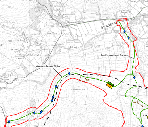
Two potential access routes to the Site are being considered:
Northern Access Option
Western Access Option
Access to the Site would be taken from the A822 via one of these options.
Both options have been considered as part of the EIA. It is expected that only one of these options will be constructed should consent be granted.
The proposed access tracks options are shown on EIA Figure 1.2: Site Layout (extract from Figure 1.2 here for ease of reference).
Northern Access Option
Existing access into the Site is primarily from the A822 to the north, and just to the east of the Northern Access Option junction. This existing track provides access into the Site, as well as branching off to the southeast towards Little Glenshee. The track also serves residential properties.
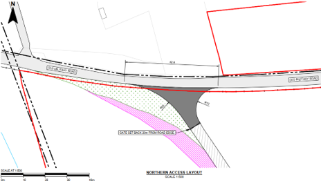
If the Northern Access Option is used, a new junction would be required at the A822, together with a more substantial bridge structure approximately 30 m in length to cross the River Braan and address topography considerations. In addition, a link road would be required from the substation to any grid infrastructure near Girron in the west of the Site, assuming that any connection to the grid ties into the existing 132 kV overhead line in this location (Option 1 (See Appendix 4.1).
However, this track would not necessarily require an additional junction with the public road and would be built to heavy goods vehicle (HGV) specification during the construction phase of the development and retained as such (not Abnormal Indivisible Load (AIL) standard). (Extract of EIA Figure 4.2, which shows the northern access and visibility splay, is set out here for ease of reference.)
Western Access Option
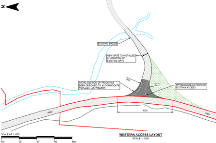
The existing junction at Girron would be upgraded as the Western Access Option, which serves one vacant residential property and a steading complex. It also provides access to a telecoms mast and is a Core Path.
This access option, whilst longer in track length to get to the construction compound and more visually prominent, would require a lesser replacement of the existing bridge crossing the Girron Burn and would be located on fairly gently sloping terrain. This reduced strain (and fuel consumption) on HGV movements and AIL deliveries.
Extract of EIA Figure 4.1 which shows the western access and visibility splay is set out here for ease of reference.
6.1 Onsite Access Tracks
Approximately 1.9 km of existing tracks would be utilised at the Site.
18.8 km of new on-site tracks would link the proposed turbines and infrastructure to the public road (A822).
Each track would have an approximate running width of 5.5m. Track widths may also be wider for short sections, such as lengths with passing places and at bends and track junctions.
In addition, there would be a requirement for drainage channels along one or both sides of each section of track, depending on the ground conditions along each track segment. Tracks would be designed with a crossfall, towards the drainage ditches, to prevent the build-up of water on the running surface, and to control surface water run off to designated drainage channels.
The internal tracks would provide access for construction activities (including cable installation), as well as operation, maintenance and eventual decommissioning.
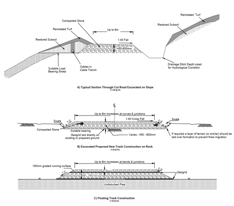
Tracks may be excavated (cut and fill) to achieve a save running surface on areas where gradients require this. They may be installed directly onto bedrock after the removal and appropriate nearby storage or reinstatement of soils. Where required and to minimise disturbance to peatland and areas of peat deeper than 1 m, tracks will be floated were possible to do so.
An extract of Figure 4.10, which illustrates an indicative track design for a cross section of a track on an excavated slope, for a track construction directly onto bedrock, and for a floating track construction, is included here for ease of reference.
Access during construction and decommissioning
Public access across the network of core paths and rights of way would be managed during construction and decommissioning works for the Proposed Development. This is to ensure ongoing access across the area (taking account of the right to roam) whilst ensuring the safety of the public using onsite tracks, and other rights of way.
Recreational access would be managed through an access management plan, including any temporary diversions or temporary closures during intense periods of construction.
These measures will be short‑term and communicated in advance through on‑site signage and engagement with relevant stakeholders.
6.2 Public Access (and access during operation)
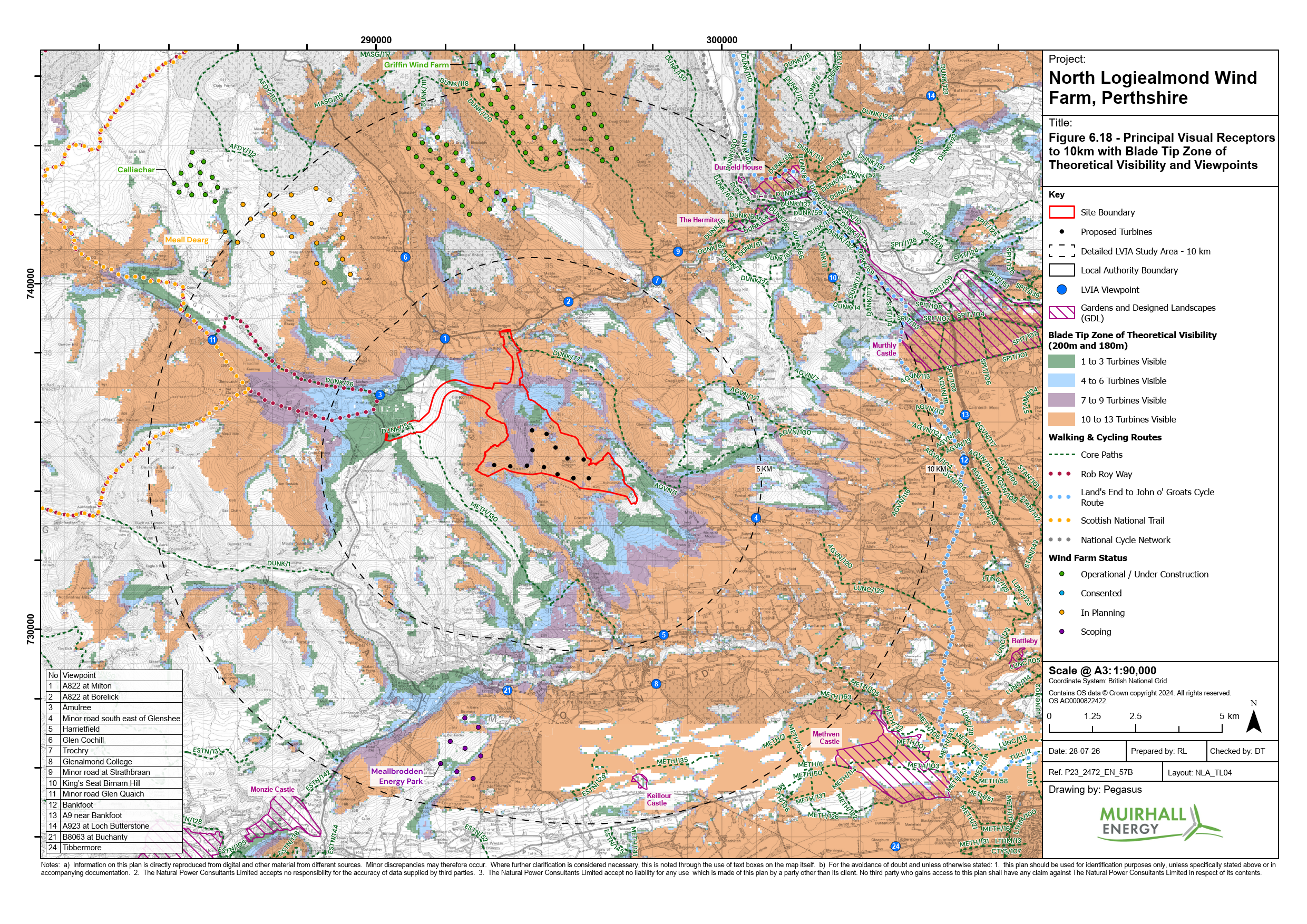
There are a number of public rights of way and core paths through and around the Site. These are set out in EIA Figure 6.18 (Figure 1) Principal Visual Receptors to 10km, and an extract is included for ease of reference.
There are several core paths and promoted recreational routes in close proximity to the Site.
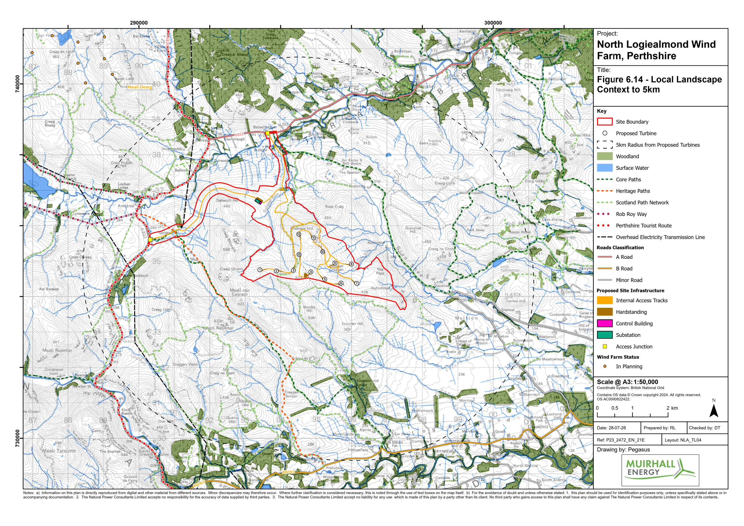
The Core Path DUNK/155 and METH/130 (overlapped by TP92, Scottish Hill Tracks route SHT(6)129, and ‘Old Road to Amulree’ Heritage Path) is located to the west of the Site. This crosses the western access option as illustrated on EIA Figure 6.18 (Figure 1).
Core Path DUNK/77 and AGVN/1 (overlapped by TP93 and Scottish Hill Tracks route SHT(6)130) is located to the north of the Site, and crosses the northern access option before running north east of the Site.
The Applicant is committed to working with the Landowner to enable safe and easy access to tracks within the Site for leisure and recreation. This will include promoting safe areas for parking where possible, which do not impact wind farm or estate operations, clear signage and promotion of onward connections where possible.
Other core paths and long distance routes in the LVIA study area (EIA Chapter 6) include:
The Rob Roy Way (partly overlapped with Core Path DUNK/76, TP91, SHT(6) 127a, SHT(6)129, and Kenmore to Amulree Heritage Path) is a long distance path between Drymen and Pitlochry.
Core Paths AGVN/100 and AGVN/121 form a circular route to the northeast of Little Glenshee and to the east of the proposed turbines. The route connects Glen Shee with Moine Folaich to the north via Loch Tullybelton and Glack Farm.
Core Path DUNK/120 skirts the southern edge of the northernmost Griffin Wind Farm turbines before passing into coniferous forest and emerging on open south facing fields at Outfields of Logie where it descends to the minor road south of Ballinlick.
Core Path DUNK/15 travels from the Hermitage car park and follows an Old Military Road to Rumbling Bridge.
Core Path DUNK/11 and DUNK/14 combine to form a circular route to the summit of Birnam Hill at Kings Seat. The route travels from Birnam, near the rail station, and heads south to climb the wooded slopes of Birnam Hill to Kings Seat in an elevated clearing. From Kings Seat, the route continues south through areas of dispersed forestry, before following contours east and north along gently falling slopes, before turning northwest along the lower slopes and following the course of the rail line back to Birnam Station.
Core Path DUNK/61 travels from Tomgarrow south of the A822 to Ladywell Plantation. This short (1.1 km) route forms part of several interconnected core paths to the south of the Hermitage and within Tay Forest Park.
Core Path AGVN/120 and LUNC/129 form a route between Gourdiehill and Saddlebrae Wood following an access track that passes Woodend & Blackhill..
The Heritage Path – General Wade’s Military Road, Crieff to Aberfeldy is located to the west of the Proposed Development.

In addition to the core paths, a number of Scotland Path Networks traverse the Site, however, none of these are core paths. During operation, the wind farm access tracks, including the Scotland Path Network would be available for use by the public. This would promote a number of circular access routes within and around the Site as illustrated on the extract above. The Applicant will work with communities to maximise benefits to local communities and visitors in a safe and responsible manner.